Development of Methods for Using Satellite, Computer, and Other Information Technology for Environmental Problems in Siberia: As International Joint Projects The aim of my research is to develop an algorithm for compiling real-time satellite data received from three stations in Siberia, Alaska, and Tohoku University into an image database at CNEAS that is then used to build a wide-area monitoring system for locating and dealing with environmental problems in Siberia. This system will require combining expertise from a wide range of specialized fields, including knowledge not only about satellite orbits and sensors but also about large-scale satellite image processing and the latest network and computer information processing technologies. The system is already being used to monitor forest fires in Siberia and other areas of North Asia, where it has proved particularly successful in observing the effects on Japan of drifting smoke from such fires. 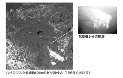 A forest fire observed near Lake Zeya, approximately 800 kilometers northwest of Khabarovsk (21 June 1999) / View from an airplane Principal areas of interest
|


동북대학
동북아시아연구센터
(우)980-8576
일본국 미야기현 센다이시 아오바구 가와우치 41번지
FAX : (022) 795-6010