Development of Methods for Using Satellite, Computer, and Other Information Technology for Environmental Problems in Siberia: As International Joint Projects The aim of my research is to develop an algorithm for compiling real-time satellite data received from three stations in Siberia, Alaska, and Tohoku University into an image database at CNEAS that is then used to build a wide-area monitoring system for locating and dealing with environmental problems in Siberia. This system will require combining expertise from a wide range of specialized fields, including knowledge not only about satellite orbits and sensors but also about large-scale satellite image processing and the latest network and computer information processing technologies. 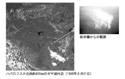 A forest fire observed near Lake Zeya, approximately 800 kilometers northwest of Khabarovsk (21 June 1999) / View from an airplane Principal areas of interest
|


Центр исследований Северо-Восточной Азии (ЦИСВА/CNEAS)
41 Kawauchi Aoba-ku,
Sendai Miyagi, 980-8576, Japan
Tel: +81-22-795-6009,3707
Fax: +81-22-795-6010